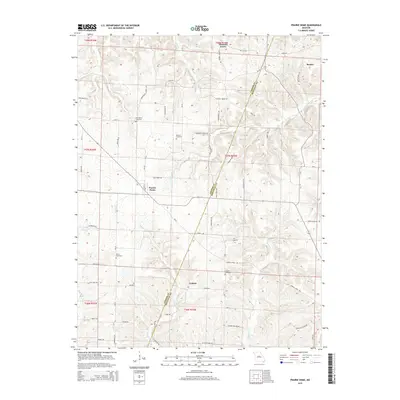
2015 Map of Prairie Home
USGS Topo · Published 2015About this map
The agricultural uplands of Missouri where Cooper Co and Moniteau Co meet are centered on the community of Prairie Home. This landscape is defined by its rural settlements and a dense network of local roads such as Big Lick Rd and Ridge Rd that navigate the drainages of Wolf Cr, Splice Cr, and Howard Cr. Historical continuity is evident in the many family and community burial grounds, including Providence Cemetery and Garman Cemetery, which anchor the small crossroads hamlets of Pleasant Grove, Cedron, and Renfro. The map reveals a highly structured rural environment where section lines and local thoroughfares like Providence School Dr and Robinson School Rd reflect the enduring legacy of early educational and religious centers in this part of the state.
Find a feature on this map
54 named features on this map. Tap any name to fly to it.
Don’t see what you’re looking for? This feature index may not catch every label — zoom into the map to look around manually.
Map Details
Editions of this 2015 Prairie Home Map
This is the sole edition of this map. No revisions or reprints were ever made.
Other maps of this area

1886 · Jefferson City
USGS Topo · 1:125,000

1888 · Boonville
USGS Topo · 1:125,000

1894 · Jefferson City
USGS Topo · 1:125,000

1947 · Jefferson City
USGS Topo · 1:250,000

1948 · Centertown
USGS Topo · 1:62,500

1948 · Columbia
USGS Topo · 1:62,500
1949 · Centertown
USGS Topo · 1:62,500

1950 · Columbia
USGS Topo · 1:62,500

1952 · Rocheport
USGS Topo · 1:24,000

1952 · Boonville
USGS Topo · 1:24,000