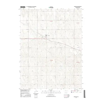
2015 Map of Prairie View
USGS Topo · Published 2015About this map
Prairie View serves as the central hub of this northern Kansas landscape, situated where the local road network converges. The township is characterized by a series of north-south and east-west routes named after Indigenous peoples, such as W Navajo Rd, W Osage Rd, and W Mohawk Rd. These thoroughfares divide the agricultural plains and manage the drainage of several local waterways including Beaver Cr, Deer Cr, and Wildcat Cr. For genealogists, the map provides precise locations for the Prairie View Cem and the Luctor Cem further north. The presence of the Van Pak Airport just east of the main settlement reflects the modern aviation infrastructure supporting this rural Phillips County community, while the rectilinear survey grid of t2s r20w and surrounding townships preserves the original land division patterns of the High Plains.
Find a feature on this map
24 named features on this map. Tap any name to fly to it.
Don’t see what you’re looking for? This feature index may not catch every label — zoom into the map to look around manually.
Map Details
Editions of this 2015 Prairie View Map
This is the sole edition of this map. No revisions or reprints were ever made.
Other maps of this area

1893 · Norton
USGS Topo · 1:125,000

1893 · Phillipsburg
USGS Topo · 1:125,000

1955 · Beloit
USGS Topo · 1:250,000

1959 · Beloit
USGS Topo · 1:250,000
1967 · Almena
USGS Topo · 1:24,000
1967 · Long Island
USGS Topo · 1:24,000

1968 · Woodruff
USGS Topo · 1:24,000

1972 · Speed
USGS Topo · 1:24,000
1973 · Stuttgart
USGS Topo · 1:24,000

1978 · Logan
USGS Topo · 1:24,000