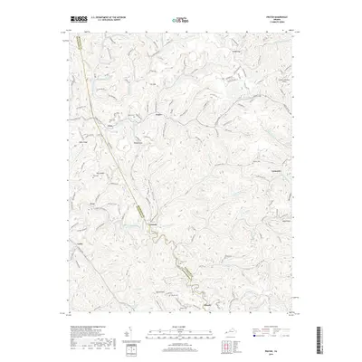
2019 Map of Prater
USGS Topo · Published 2019About this map
Russell Fork and its numerous mountain tributaries carve through this corner of Buchanan and Dickenson Counties. The settlement of Vicey sits at a critical junction near Lovers Gap, while Prater occupies the central valley along Russell Prater Cr. The landscape is defined by its deep hollows and high ridges, such as Rakes Ridge and Boyd Ridge, which dictated the early winding road patterns and small, isolated communities. For genealogists, the map is a significant resource for locating small family burial grounds, including Deel Cem, Owens Cem, and Viers Cem, which are scattered among the steep terrain and narrow bottomlands. In the northeast, the presence of the Grundy Municipal Airport marks a modern development in an otherwise deeply traditional Appalachian coalfield landscape, providing a sharp contrast to the older hamlets like Viers and Cannady.
Find a feature on this map
153 named features on this map. Tap any name to fly to it.
Don’t see what you’re looking for? This feature index may not catch every label — zoom into the map to look around manually.
Map Details
Editions of this 2019 Prater Map
This is the sole edition of this map. No revisions or reprints were ever made.
Other maps of this area

1886 · Grundy
USGS Topo · 1:125,000

1890 · Grundy
USGS Topo · 1:125,000

1892 · Grundy
USGS Topo · 1:125,000

1913 · Clintwood
USGS Topo · 1:62,500

1914 · Bucu
USGS Topo · 1:48,000

1914 · Hurley
USGS Topo · 1:48,000

1915 · Clintwood
USGS Topo · 1:62,500

1915 · Regina
USGS Topo · 1:48,000

1915 · Hurley
USGS Topo · 1:48,000

1916 · Bucu
USGS Topo · 1:62,500