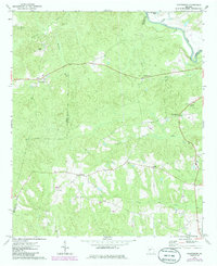
1971 Map of Prattsburg
USGS Topo · Published 1985About this map
Prattsburg and Carsonville anchor the northern reaches of this topographic survey, which documents the rural landscape of Taylor County and its borders with Talbot and Upson counties. The terrain is defined by the sharp descent toward the Flint River in the northeast corner, where Swift Creek and Three Fingered Lake meet the river's edge. This 1970s record highlights a network of small agricultural communities and family-centered landmarks, including Wesley and Jarrell to the south. The distribution of rural houses and landmarks like Crossroad Ch and Antioch Ch reflects a settlement pattern tied to the creeks and ridges, such as those surrounding Little Patsiliga Creek and Timms Creek. A solitary Landing Strip near Richland Creek and a Roadside Park near Five Points indicate the modest infrastructure serving this corner of Georgia as it appeared in the early 1970s.
Find a feature on this map
24 named features on this map. Tap any name to fly to it.
Don’t see what you’re looking for? This feature index may not catch every label — zoom into the map to look around manually.
Map Details
Editions of this 1971 Prattsburg Map
2 editions found
Other maps of this area

1935 · Thomaston
USGS Topo · 1:48,000

1939 · Thomaston
USGS Topo · 1:62,500

1951 · Yatesville
USGS Topo · 1:62,500

1955 · Phenix City
USGS Topo · 1:250,000

1957 · Phenix City
USGS Topo · 1:250,000

1958 · Phenix City
USGS Topo · 1:250,000
1971 · Roland
USGS Topo · 1:24,000

1971 · Prattsburg
USGS Topo · 1:24,000
1971 · Baldwinville
USGS Topo · 1:24,000
1971 · Lincoln Park
USGS Topo · 1:24,000