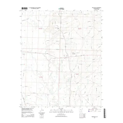
2014 Map of Prattsville
USGS Topo · Published 2014About this map
Prattsville and the small settlement of Buie anchor this Grant County landscape, where the meandering course of the Saline River defines the local geography. The river's influence is evident in the numerous wetland features and drainage patterns, including Moores Slough and Stephens Lake. This 2014 survey captures a rural network of county roads and family-named routes such as Mooney Trl and Dunn Trl, which connect isolated homesteads and forested tracts. The terrain is crisscrossed by several significant waterways, including Polk Cr, Francois Cr, and Huskey Cr, illustrating a complex hydrological system that has shaped the area's development. Local history is etched into the landscape through the numerous named roads, such as Co Road 590 and Grant 451 Rd, which provide access to the timberlands and agricultural plots characteristic of this part of Arkansas.
Find a feature on this map
87 named features on this map. Tap any name to fly to it.
Don’t see what you’re looking for? This feature index may not catch every label — zoom into the map to look around manually.
Map Details
Editions of this 2014 Prattsville Map
This is the sole edition of this map. No revisions or reprints were ever made.
Other maps of this area

1955 · Little Rock
USGS Topo · 1:250,000

1956 · Little Rock
USGS Topo · 1:250,000

1960 · Little Rock
USGS Topo · 1:250,000

1963 · Traskwood
USGS Topo · 1:24,000

1963 · Prattsville
USGS Topo · 1:24,000
1963 · Tull
USGS Topo · 1:24,000

1964 · Poyen
USGS Topo · 1:24,000

1964 · Little Rock
USGS Topo · 1:250,000

1964 · Sheridan
USGS Topo · 1:24,000

1964 · Belfast
USGS Topo · 1:24,000