
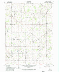
1962 Map of Preble
USGS Topo · Published 1963About this map
The agricultural landscape of Jefferson and Preble townships is defined by an intricate network of drainage systems like the Eightmile No 2 Ditch and Lambert Ditch, essential for the high-yield farming of the Indiana plains. Small crossroads communities and rail stops anchor the rural economy, particularly along the Erie-Lackawanna and the Chicago and St Louis New York railroad lines. These tracks connect the elevators and homes of Tocsin, Magley, and Preble to the wider region.
Find a feature on this map
56 named features on this map. Tap any name to fly to it.
Don’t see what you’re looking for? This feature index may not catch every label — zoom into the map to look around manually.
Map Details
Editions of this 1962 Preble Map
2 editions found
Other maps of this area

1911 · Berne
USGS Topo · 1:48,000

1953 · Muncie
USGS Topo · 1:250,000

1956 · Muncie
USGS Topo · 1:250,000

1961 · Hoagland
USGS Topo · 1:24,000

1962 · Poe
USGS Topo · 1:24,000

1962 · Uniondale
USGS Topo · 1:24,000

1962 · Ossian
USGS Topo · 1:24,000

1962 · Berne
USGS Topo · 1:24,000
1962 · Decatur
USGS Topo · 1:24,000

1962 · Linn Grove
USGS Topo · 1:24,000