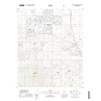
2018 Map of Prescott Valley South
USGS Topo · Published 2018About this map
Prescott Valley and the surrounding high desert of Yavapai County are captured in this 2018 survey, reflecting a landscape where suburban growth meets the expansive Prescott National Forest. The map documents the educational footprint of the region, featuring both the Yavapai College Prescott Valley Campus and Northern Arizona Univ Yavapai. To the south, the topography shifts from the residential grids of Blue Hills Farms and Dewey-Humboldt toward the rugged drainages of Salida Gulch and Charcoal Gulch. This modern record is particularly detailed regarding water infrastructure, marking numerous stock tanks and reservoirs like Mesa Reservoir and White Horse Tank that support the arid environment. The presence of the Agua Fria River and Lynx Cr underscores the importance of these drainage systems to the development of Diamond Valley and the foothills of Glassford Hill.
Find a feature on this map
80 named features on this map. Tap any name to fly to it.
Don’t see what you’re looking for? This feature index may not catch every label — zoom into the map to look around manually.
Map Details
Editions of this 2018 Prescott Valley South Map
This is the sole edition of this map. No revisions or reprints were ever made.
Other maps of this area

1887 · Prescott
USGS Topo · 1:250,000

1892 · Prescott
USGS Topo · 1:250,000

1903 · Bradshaw Mountains
USGS Topo · 1:125,000

1905 · Jerome
USGS Topo · 1:125,000

1944 · Mingus Mountain
USGS Topo · 1:62,500

1947 · Mingus Mtn
USGS Topo · 1:62,500

1947 · Mayer
USGS Topo · 1:62,500

1947 · Mt. Union
USGS Topo · 1:62,500

1947 · Prescott
USGS Topo · 1:62,500

1948 · Mt. Union
USGS Topo · 1:63,360
Featured Places
- Prescott Valley, AZ
- Dewey-Humboldt, AZ
- Blue Hills Farms, Dewey-Humboldt
- Yavapai County, AZ
- United States