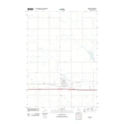
2012 Map of Presho
USGS Topo · Published 2012About this map
Presho serves as a central hub in Lyman County, situated at the intersection of local routes and the modern Interstate 90 corridor. This 2012 survey illustrates the town's grid, featuring streets like S Birch and Railway St, as well as its proximity to Medicine Cr. The landscape is defined by the gentle drainage of Stony Butte Cr and Nail Cr, alongside the elevated Ringneck Rdg to the southeast. Local history is anchored by the Medicine Creek Cem and Holy Angels Cem, providing valuable points of reference for genealogists. The map also documents significant infrastructure such as the Presho Municipal Airport and the water management at Fate Dam, capturing the balance between rural agricultural land and the community's essential services in the early 21st century.
Find a feature on this map
23 named features on this map. Tap any name to fly to it.
Don’t see what you’re looking for? This feature index may not catch every label — zoom into the map to look around manually.
Map Details
Editions of this 2012 Presho Map
This is the sole edition of this map. No revisions or reprints were ever made.
Other maps of this area

1953 · Huron
USGS Topo · 1:250,000

1954 · Pierre
USGS Topo · 1:250,000

1954 · Huron
USGS Topo · 1:250,000

1955 · Martin
USGS Topo · 1:250,000

1955 · Mitchell
USGS Topo · 1:250,000

1958 · Pierre
USGS Topo · 1:250,000

1958 · Martin
USGS Topo · 1:250,000

1959 · Mitchell
USGS Topo · 1:250,000

1966 · Ft. George Butte SE
USGS Topo · 1:24,000
1966 · Joe Creek SW
USGS Topo · 1:24,000