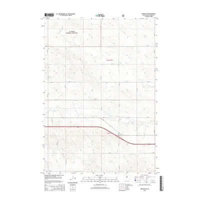
2015 Map of Presho NW
USGS Topo · Published 2015About this map
Ft. Pierre National Grassland dominates the northern reaches of this Lyman County landscape, preserving the wide-open prairie character of the Great Plains. The terrain is defined by the subtle drainage patterns of Stony Butte Cr and Medicine Cr, which meander through a section-line grid of rural roads. The map reveals a highly structured surveyor's landscape where thoroughfares like Sundance Rd and 240th St provide access to remote acreage. This 2015 edition reflects the modern management of public lands and the persistent agricultural layout established during the initial settlement of the region. It serves as a clear record of the intersection between federal land conservation and the local rural infrastructure of central South Dakota.
Find a feature on this map
20 named features on this map. Tap any name to fly to it.
Don’t see what you’re looking for? This feature index may not catch every label — zoom into the map to look around manually.
Map Details
Editions of this 2015 Presho NW Map
This is the sole edition of this map. No revisions or reprints were ever made.
Other maps of this area

1954 · Pierre
USGS Topo · 1:250,000

1955 · Martin
USGS Topo · 1:250,000

1958 · Pierre
USGS Topo · 1:250,000

1958 · Martin
USGS Topo · 1:250,000

1966 · Ft. George Butte SE
USGS Topo · 1:24,000

1967 · Ft. George Butte SW
USGS Topo · 1:24,000

1972 · Pierre 3 SE
USGS Topo · 1:24,000

1972 · Vivian
USGS Topo · 1:24,000

1972 · Vivian SE
USGS Topo · 1:24,000
1978 · Presho
USGS Topo · 1:24,000