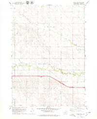
1978 Map of Presho NW
USGS Topo · Published 1979About this map
Medicine Creek winds across this Lyman County landscape, defining the central drainage basin alongside the upper reaches of Stony Butte Creek. The map documents a critical transportation corridor during the late 1970s, featuring the path of the Chicago Milwaukee St Paul and Pacific railroad as it parallels the water. This alignment illustrates the historical reliance on natural valleys for rail infrastructure in the South Dakota plains. The area is divided between the administrative boundaries of Lund and Moore, with the modern footprint of Interstate 90 cutting across the southern half of the sheet. Two designated Rest Area sites along the highway signify the transition from the steam-era rail economy to the mid-century dominance of the interstate system.
Find a feature on this map
7 named features on this map. Tap any name to fly to it.
Don’t see what you’re looking for? This feature index may not catch every label — zoom into the map to look around manually.
Map Details
Editions of this 1978 Presho NW Map
This is the sole edition of this map. No revisions or reprints were ever made.
Other maps of this area

1954 · Pierre
USGS Topo · 1:250,000

1955 · Martin
USGS Topo · 1:250,000

1958 · Pierre
USGS Topo · 1:250,000

1958 · Martin
USGS Topo · 1:250,000

1966 · Ft. George Butte SE
USGS Topo · 1:24,000

1967 · Ft. George Butte SW
USGS Topo · 1:24,000

1972 · Pierre 3 SE
USGS Topo · 1:24,000

1972 · Vivian
USGS Topo · 1:24,000

1972 · Vivian SE
USGS Topo · 1:24,000
1978 · Presho
USGS Topo · 1:24,000