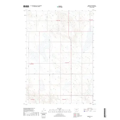
2017 Map of Presho SE
USGS Topo · Published 2017About this map
Mill Iron Cr winds through this section of the Great Plains in Lyman County, defining a landscape of rolling prairie and seasonal wetlands. The 2017 survey reflects the enduring Public Land Survey System structure, with a rigorous grid of section lines and gravel roads such as 304th Ave and 248th St providing access to the vast agricultural holdings. In the southwest corner, the headwaters of Mission Cr emerge, cutting small draws into the higher ground. The map reveals an intricate network of hundreds of small depressional wetlands and ponds scattered across the township, illustrating the complex hydrology of this prairie pothole region. This documentation provides a precise record of rural infrastructure and water distribution as it existed in the late 2010s.
Find a feature on this map
17 named features on this map. Tap any name to fly to it.
Don’t see what you’re looking for? This feature index may not catch every label — zoom into the map to look around manually.
Map Details
Editions of this 2017 Presho SE Map
This is the sole edition of this map. No revisions or reprints were ever made.
Other maps of this area

1951 · Presho 4 NE
USGS Topo · 1:24,000

1951 · Ideal NW
USGS Topo · 1:24,000

1951 · Presho 4 NW
USGS Topo · 1:24,000

1955 · Martin
USGS Topo · 1:250,000

1955 · Mitchell
USGS Topo · 1:250,000

1958 · Martin
USGS Topo · 1:250,000

1959 · Mitchell
USGS Topo · 1:250,000
1978 · Presho
USGS Topo · 1:24,000
1978 · Brakke Dam
USGS Topo · 1:24,000

1978 · Kennebec SW
USGS Topo · 1:24,000