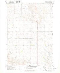
1978 Map of Presho SE
USGS Topo · Published 1979About this map
Iron Mill Creek and Mill Creek dominate the drainage patterns of this central South Dakota landscape, where the land is organized into the expansive townships of Presho, Liberty, and Earling. This 1970s survey captures a rural environment defined by sectional grid lines and isolated landmarks like the Smith Landing Strip. The topography shows a series of draws and ridges leading toward Mission Creek in the south, reflecting the agrarian structure of Pratt and Sylvia townships. This map is a clear record of the high plains cadastral system, showing how the townships of Hilmore and its neighbors were surveyed and utilized during the late twentieth century.
Find a feature on this map
10 named features on this map. Tap any name to fly to it.
Don’t see what you’re looking for? This feature index may not catch every label — zoom into the map to look around manually.
Map Details
Editions of this 1978 Presho SE Map
This is the sole edition of this map. No revisions or reprints were ever made.
Other maps of this area

1951 · Presho 4 NE
USGS Topo · 1:24,000

1951 · Ideal NW
USGS Topo · 1:24,000

1951 · Presho 4 NW
USGS Topo · 1:24,000

1955 · Martin
USGS Topo · 1:250,000

1955 · Mitchell
USGS Topo · 1:250,000

1958 · Martin
USGS Topo · 1:250,000

1959 · Mitchell
USGS Topo · 1:250,000
1978 · Presho
USGS Topo · 1:24,000
1978 · Brakke Dam
USGS Topo · 1:24,000

1978 · Kennebec SW
USGS Topo · 1:24,000