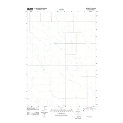
2012 Map of Presho SW
USGS Topo · Published 2012About this map
Lyman County land south of the White River remains sparsely populated in this 2012 survey, defined by a fine-grained network of intermittent stream channels and a rigid section-line road grid. The high prairie plateau is marked by numerous small depressions and natural drainage patterns that flow toward larger tributaries beyond the quadrangle boundary. Human presence is subtle across this agricultural landscape, centered on the Hilmoe Cem located along the southern edge of the sheet. This rural site serves as a primary landmark for local history and genealogical research in an area dominated by open range and tilled fields.
Find a feature on this map
1 named feature on this map. Tap any name to fly to it.
Don’t see what you’re looking for? This feature index may not catch every label — zoom into the map to look around manually.
Map Details
Editions of this 2012 Presho SW Map
This is the sole edition of this map. No revisions or reprints were ever made.
Other maps of this area

1951 · Badnation
USGS Topo · 1:24,000

1951 · Presho 4 NE
USGS Topo · 1:24,000

1951 · Presho 4 NW
USGS Topo · 1:24,000

1955 · Martin
USGS Topo · 1:250,000

1958 · Martin
USGS Topo · 1:250,000

1972 · Vivian
USGS Topo · 1:24,000

1972 · Vivian SE
USGS Topo · 1:24,000
1978 · Presho
USGS Topo · 1:24,000
1978 · Presho SE
USGS Topo · 1:24,000

1978 · Presho SW
USGS Topo · 1:24,000