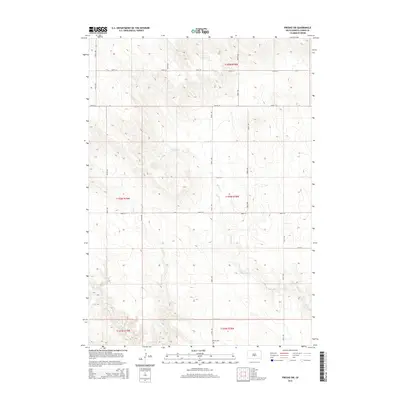
2015 Map of Presho SW
USGS Topo · Published 2015About this map
Hillmoe Cem stands as a focal point for genealogical interest in this rural portion of Lyman County, situated near the intersection of 299th Ave and 251st St. The landscape is defined by the drainage patterns of Mission Cr and Sedan Cr, which carve through the undulating terrain of the northern Great Plains. This 2015 U.S. Geological Survey representation of the area southwest of Presho illustrates a highly organized township and range grid system, where section lines are frequently traced by gravel roads such as 244th St and 301st Ave. The map provides a precise record of the land divisions and minor watercourses that have shaped the agricultural development of this South Dakota region since its early settlement.
Find a feature on this map
19 named features on this map. Tap any name to fly to it.
Don’t see what you’re looking for? This feature index may not catch every label — zoom into the map to look around manually.
Map Details
Editions of this 2015 Presho SW Map
This is the sole edition of this map. No revisions or reprints were ever made.
Other maps of this area

1951 · Badnation
USGS Topo · 1:24,000

1951 · Presho 4 NE
USGS Topo · 1:24,000

1951 · Presho 4 NW
USGS Topo · 1:24,000

1955 · Martin
USGS Topo · 1:250,000

1958 · Martin
USGS Topo · 1:250,000

1972 · Vivian
USGS Topo · 1:24,000

1972 · Vivian SE
USGS Topo · 1:24,000
1978 · Presho
USGS Topo · 1:24,000
1978 · Presho SE
USGS Topo · 1:24,000

1978 · Presho SW
USGS Topo · 1:24,000