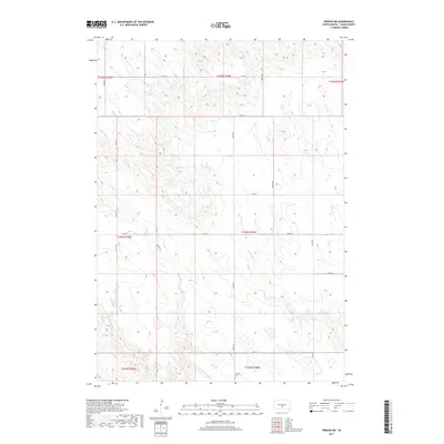
2017 Map of Presho SW
USGS Topo · Published 2017About this map
Hilmoe Cem stands as a quiet cultural landmark in this rural landscape of Lyman County, South Dakota. This area is defined by the winding paths of Mission Cr and Scallion Cr, which cut through the terrain of the Missouri Plateau. The map reveals a strict geometric grid of section lines and local roads, including 295th Ave and 244th St, that delineate the agricultural layout of the Great Plains. Apart from the cemetery, which provides a point of interest for genealogists and local historians, the landscape is primarily dominated by drainage patterns and the path of Hwy 26 as it crosses the northern sections of the township. The survey highlights the intersection of natural watercourses and the human-imposed township and range system common across the Dakotas.
Find a feature on this map
23 named features on this map. Tap any name to fly to it.
Don’t see what you’re looking for? This feature index may not catch every label — zoom into the map to look around manually.
Map Details
Editions of this 2017 Presho SW Map
This is the sole edition of this map. No revisions or reprints were ever made.
Other maps of this area

1951 · Badnation
USGS Topo · 1:24,000

1951 · Presho 4 NE
USGS Topo · 1:24,000

1951 · Presho 4 NW
USGS Topo · 1:24,000

1955 · Martin
USGS Topo · 1:250,000

1958 · Martin
USGS Topo · 1:250,000

1972 · Vivian
USGS Topo · 1:24,000

1972 · Vivian SE
USGS Topo · 1:24,000
1978 · Presho
USGS Topo · 1:24,000
1978 · Presho SE
USGS Topo · 1:24,000

1978 · Presho SW
USGS Topo · 1:24,000