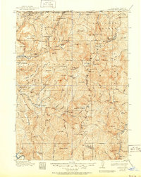
1922 Map of Preston Peak
USGS Topo · Published 1951About this map
Siskiyou National Forest dominates this mountain landscape, which was surveyed in 1915 as a rugged frontier of mining and early ranching. The Smith River and its numerous forks carve through steep ridges like Ship Mountain Ridge and Monumental Ridge, creating a geography defined by isolated bars and camps. Historic mining operations, including the Cleopatra Mine and Higgins Copper, highlight the area's extraction history, while scattered habitations like Washington Ranch and Herrington Ranch indicate where early settlers found footing in the river valleys.
Find a feature on this map
122 named features on this map. Tap any name to fly to it.
Don’t see what you’re looking for? This feature index may not catch every label — zoom into the map to look around manually.
Map Details
Editions of this 1922 Preston Peak Map
5 editions found
Other maps of this area

1908 · Grants Pass
USGS Topo · 1:125,000

1914 · Seiad
USGS Topo · 1:125,000

1917 · Kerby
USGS Topo · 1:125,000

1918 · Kerby
USGS Topo · 1:125,000

1922 · Preston Peak
USGS Topo · 1:125,000

1922 · Seiad
USGS Topo · 1:125,000

1925 · Hoopa
USGS Topo · 1:125,000

1929 · Crescent City
USGS Topo · 1:125,000

1945 · Ship Mountain
USGS Topo · 1:62,500

1945 · Orick
USGS Topo · 1:62,500