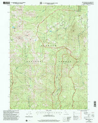
2001 Map of Preston Peak
USGS Topo · Published 2004About this map
Preston Peak stands as the dominant summit in this high-elevation corner of the Klamath National Forest, where the complex geology of the Klamath Mountains is on full display. The landscape is defined by the protected wilderness of the Siskiyou Wilderness, featuring a network of glacial cirques and alpine basins like Cedar Basin and Rattlesnake Meadow. Water systems are central to the geography, with South Fork Indian Creek and Clear Creek draining the steep slopes, while smaller features such as Raspberry Lake and Elk Lick indicate the varied hydrology of the region. The map preserves the 2001 wilderness and wild river boundaries, including the Klamath and Wild Scenic River Boundary, which protects the pristine character of the waterways. Significant peaks such as El Capitan, Copper Mtn, and Boulder Peak ring the central drainage, marking a terrain where early mining and fire lookout access once dictated the few trails and gaps, such as Cyclone Gap, that traverse these ridges.
Find a feature on this map
31 named features on this map. Tap any name to fly to it.
Don’t see what you’re looking for? This feature index may not catch every label — zoom into the map to look around manually.
Map Details
Editions of this 2001 Preston Peak Map
This is the sole edition of this map. No revisions or reprints were ever made.
Other maps of this area

1914 · Seiad
USGS Topo · 1:125,000

1922 · Preston Peak
USGS Topo · 1:125,000

1922 · Seiad
USGS Topo · 1:125,000

1948 · Weed
USGS Topo · 1:250,000

1950 · Weed
USGS Topo · 1:250,000

1955 · Dillon Mtn
USGS Topo · 1:62,500

1955 · Ukonom Lake
USGS Topo · 1:62,500

1956 · Happy Camp
USGS Topo · 1:62,500

1956 · Preston Peak
USGS Topo · 1:62,500

1958 · Weed
USGS Topo · 1:250,000