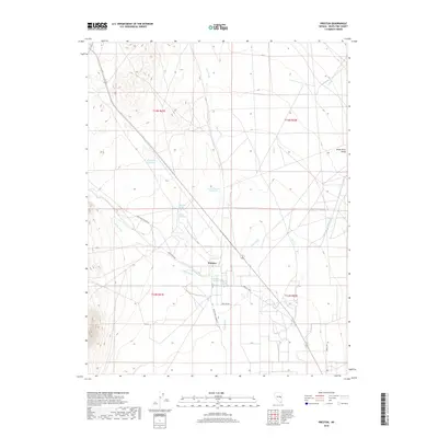
2018 Map of Preston
USGS Topo · Published 2018About this map
Preston sits at a critical hydrologic junction in the White River Valley, where a network of perennial springs and intermittent washes supports life in this arid basin. This 2018 survey documents the intricate water management system essential to the area, featuring named sources like Preston Big Spring, Arnoldson Spring, and Nicholas Spring. These waters feed into the White River and are captured by local infrastructure including the Blackjack Reservoir and Lower Preston Reservoir. The settlement pattern follows the gentle contours of the valley floor, connected by local routes such as White River Rd and Preston Loop. This map reveals how the availability of water at features like McQuinty Spring and Cold Spring dictates the placement of roads and homesteads within the larger drainages of Jakes Wash and Eph Cr.
Find a feature on this map
23 named features on this map. Tap any name to fly to it.
Don’t see what you’re looking for? This feature index may not catch every label — zoom into the map to look around manually.
Map Details
Editions of this 2018 Preston Map
This is the sole edition of this map. No revisions or reprints were ever made.
Other maps of this area

1952 · Ely
USGS Topo · 1:125,000

1956 · Lund
USGS Topo · 1:250,000

1956 · Ely
USGS Topo · 1:250,000

1958 · Ely
USGS Topo · 1:62,500

1959 · Ely
USGS Topo · 1:250,000

1959 · Preston Reservoir
USGS Topo · 1:62,500

1960 · Lund
USGS Topo · 1:250,000

1963 · Ely
USGS Topo · 1:250,000
1977 · Brown Knoll
USGS Topo · 1:24,000
1977 · Sawmill Canyon
USGS Topo · 1:24,000