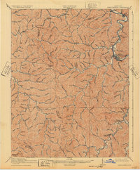
1918 Map of Prestonsburg
USGS Topo · Published 1932About this map
Prestonsburg sits at the confluence of Middle Creek and the Levisa Fork, serving as a central hub in eastern Kentucky during this 1915 survey. The town is tied to the broader regional economy via the Chesapeake and Ohio railroad, which tracks the river's path through the deep valleys. The topography is defined by the headwaters of two major river systems, with the Licking River winding through the western portion of the map, fed by numerous branches like Rocklick Fork and Burning Fork. Local life is organized around small settlements and post offices such as Alphoretta P.O., Langley P.O., and Maytown. Educational landmarks like the Big Lick School appear in the northern reaches, while the complex boundary lines between Johnson, Magoffin, Floyd, Breathitt, and Knott counties illustrate the intricate political geography of these coal-rich highlands during the early twentieth century.
Find a feature on this map
71 named features on this map. Tap any name to fly to it.
Don’t see what you’re looking for? This feature index may not catch every label — zoom into the map to look around manually.
Map Details
Editions of this 1918 Prestonsburg Map
3 editions found

Other maps of this area

1886 · Prestonsburg
USGS Topo · 1:125,000

1889 · Salyersville
USGS Topo · 1:125,000

1890 · Whitesburg
USGS Topo · 1:125,000

1891 · Hazard
USGS Topo · 1:125,000

1891 · Salyersville
USGS Topo · 1:125,000

1892 · Whitesburg
USGS Topo · 1:125,000

1892 · Prestonsburg
USGS Topo · 1:125,000

1899 · Salyersville
USGS Topo · 1:125,000

1912 · Hindman
USGS Topo · 1:48,000

1914 · Laynesville
USGS Topo · 1:48,000