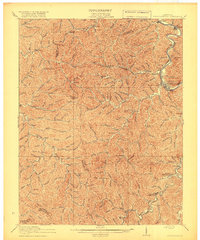
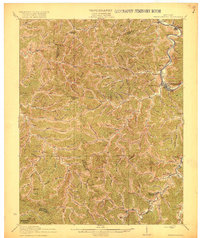
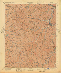
1918 Map of Prestonsburg
USGS Topo · Published 1918About this map
The Levisa Fork serves as the primary artery for commerce and transit through Floyd County during this early 20th-century period, with the Chesapeake and Ohio railroad tracking its winding course. The county seat at Prestonsburg sits as the central hub of a landscape defined by an intricate network of narrow valleys and ridges. This survey illustrates a rural economy transitioning into a more formal postal and rail infrastructure, evidenced by combined locations like Maytown Langley PO and Dinwood Alphoretta PO.
Find a feature on this map
38 named features on this map. Tap any name to fly to it.
Don’t see what you’re looking for? This feature index may not catch every label — zoom into the map to look around manually.
Map Details
Editions of this 1918 Prestonsburg Map
3 editions found
Other maps of this area

1886 · Prestonsburg
USGS Topo · 1:125,000

1889 · Salyersville
USGS Topo · 1:125,000

1890 · Whitesburg
USGS Topo · 1:125,000

1891 · Hazard
USGS Topo · 1:125,000

1891 · Salyersville
USGS Topo · 1:125,000

1892 · Whitesburg
USGS Topo · 1:125,000

1892 · Prestonsburg
USGS Topo · 1:125,000

1899 · Salyersville
USGS Topo · 1:125,000

1912 · Hindman
USGS Topo · 1:48,000

1914 · Laynesville
USGS Topo · 1:48,000