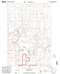
1998 Map of Pretty Rock Butte SE
USGS Topo · Published 2001About this map
Standing Rock Indian Reservation and the Cedar River National Grassland dominate this portion of the northern plains, where the land is defined by winding watercourses and isolated ranching outposts. This 1998 revision, based on earlier topographic data, illustrates a rural landscape where Cedar Creek serves as a natural boundary between Grant and Sioux Counties. The topography is marked by the distinct rises of Pretty Rock and HowE, while a network of intermittent streams like Brushy Creek, Alkali Creek, and Turtle Creek drain the open range.
Find a feature on this map
15 named features on this map. Tap any name to fly to it.
Don’t see what you’re looking for? This feature index may not catch every label — zoom into the map to look around manually.
Map Details
Editions of this 1998 Pretty Rock Butte SE Map
This is the sole edition of this map. No revisions or reprints were ever made.
Other maps of this area

1953 · McIntosh
USGS Topo · 1:250,000

1954 · Bismarck
USGS Topo · 1:250,000

1958 · Bismarck
USGS Topo · 1:250,000

1958 · McIntosh
USGS Topo · 1:250,000

1972 · Wheeler Hills
USGS Topo · 1:24,000

1972 · Coffin Buttes
USGS Topo · 1:24,000

1972 · Pretty Rock Butte
USGS Topo · 1:24,000

1972 · Morristown
USGS Topo · 1:24,000

1972 · Pretty Rock Butte SE
USGS Topo · 1:24,000

1972 · Round Top
USGS Topo · 1:24,000
Featured Places
- Porcupine District, ND
- Menz Township, Porcupine District
- Sioux County, ND
- Grant County, ND
- United States