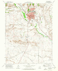
1972 Map of Price
USGS Topo · Published 1977About this map
The Price River carves a green corridor through the arid landscape of Carbon County, anchoring the regional hub of Price and the neighboring settlement of Carbonville. In the early 1970s, the town's development was defined by the Denver and Rio Grande Western railroad and an extensive network of irrigation infrastructure, including the Carbon Canal. Educational and civic life is centered around the College of Eastern Utah, Notre Dame Sch, and the Price Reeves Sch. For genealogists, the map identifies several burial grounds, including the Whitmore Cem and Mead Cem. Beyond the city grid, the terrain gives way to features like Drunkards Wash and the prominent Pinnacle, while an Old Railroad Grade offers a look at earlier transportation routes through the desert floor.
Find a feature on this map
46 named features on this map. Tap any name to fly to it.
Don’t see what you’re looking for? This feature index may not catch every label — zoom into the map to look around manually.
Map Details
Editions of this 1972 Price Map
2 editions found
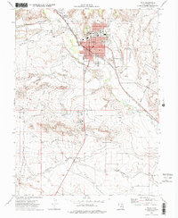
Other maps of this area

1886 · Price River
USGS Topo · 1:250,000

1896 · Price River
USGS Topo · 1:250,000

1914 · Castle Gate
USGS Topo · 1:62,500

1915 · Wellington
USGS Topo · 1:62,500

1916 · Castle Gate
USGS Topo · 1:62,500

1956 · Price
USGS Topo · 1:250,000

1960 · Price
USGS Topo · 1:250,000

1962 · Price
USGS Topo · 1:250,000

1969 · Olsen Reservoir
USGS Topo · 1:24,000

1969 · Elmo
USGS Topo · 1:24,000