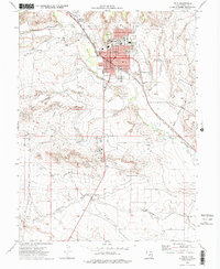
1972 Map of Price
USGS Topo · Published 1977About this map
Price serves as the regional hub of Carbon County, where the Price River and the Denver and Rio Grande Western railroad converge to dictate the valley's development. This 1970s landscape reveals an established community infrastructure, featuring the College of Eastern Utah and local institutions like the Notre Dame Sch and Durrant Sch. The surrounding geography is defined by a network of essential water management systems, including the Carbon Canal and several washes such as Hayes Wash and Meads Wash. To the northwest, the settlement of Carbonville sits near the riverbanks, while various cemeteries, such as Whitmore Cem and Mead Cem, provide points of interest for genealogical research. The presence of the County Airport and the County Industrial Center underscores the area's role as a center for transport and local industry.
Find a feature on this map
33 named features on this map. Tap any name to fly to it.
Don’t see what you’re looking for? This feature index may not catch every label — zoom into the map to look around manually.
Map Details
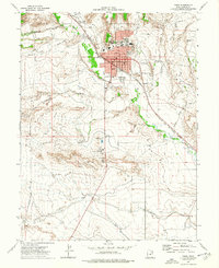
Editions of this 1972 Price Map
2 editions found
Other maps of this area

1886 · Price River
USGS Topo · 1:250,000

1896 · Price River
USGS Topo · 1:250,000

1914 · Castle Gate
USGS Topo · 1:62,500

1915 · Wellington
USGS Topo · 1:62,500

1916 · Castle Gate
USGS Topo · 1:62,500

1956 · Price
USGS Topo · 1:250,000

1960 · Price
USGS Topo · 1:250,000

1962 · Price
USGS Topo · 1:250,000

1969 · Olsen Reservoir
USGS Topo · 1:24,000

1969 · Elmo
USGS Topo · 1:24,000