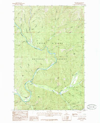
1985 Map of Prichard
USGS Topo · Published 1985About this map
The Coeur d'Alene River winds through the heart of the Coeur d'Alene National Forest, serving as the central geographic feature for this 1980s mountain interior. This region of the Shoshone Range is defined by a dense network of gulches and creeks, including the aptly named Trouble Creek and Creaky Creek, which drain the steep terrain of Sparta Peak and Prichard Peak. The small settlement at Prichard and the nearby Prichard Y serve as focal points for the few improved roads that penetrate the timbered landscape. Industrial and logistical footprints are visible through the inclusion of a Heliport near the river and a Trans Line cutting across the northwestern slopes. Local history is etched into the many family-named drainages like Uceily Gulch, George Gulch, and Me Comber Gulch, indicating a landscape long used for prospecting and timber.
Find a feature on this map
46 named features on this map. Tap any name to fly to it.
Don’t see what you’re looking for? This feature index may not catch every label — zoom into the map to look around manually.
Map Details
Editions of this 1985 Prichard Map
This is the sole edition of this map. No revisions or reprints were ever made.
Other maps of this area

1901 · Coeur D'Alene District
USGS Topo · 1:62,500

1903 · Coeur D'Alene District
USGS Topo · 1:62,500

1906 · Coeur D'Alene District
USGS Topo · 1:62,500

1909 · Cataldo
USGS Topo · 1:125,000

1911 · Cataldo
USGS Topo · 1:125,000

1932 · Trout Creek
USGS Topo · 1:125,000

1935 · Trout Creek
USGS Topo · 1:125,000

1936 · Trout Creek
USGS Topo · 1:125,000

1955 · Spokane
USGS Topo · 1:250,000

1956 · Wallace
USGS Topo · 1:250,000