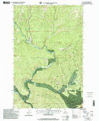
1996 Map of Prichard
USGS Topo · Published 1999About this map
Prichard Creek flows through this corner of the Coeur d'Alene National Forest in the late 1990s, revealing a landscape shaped by a century of mountain mining and forestry. Evidence of the area's extraction history is visible along the creek beds, most notably the Dredge Tailings near the junction of several gulches and the presence of an Adit near the eastern boundary. These features, alongside the Shoshone Range peaks, underscore the region's identity as a rugged industrial frontier.
Find a feature on this map
45 named features on this map. Tap any name to fly to it.
Don’t see what you’re looking for? This feature index may not catch every label — zoom into the map to look around manually.
Map Details
Editions of this 1996 Prichard Map
This is the sole edition of this map. No revisions or reprints were ever made.
Other maps of this area

1901 · Coeur D'Alene District
USGS Topo · 1:62,500

1903 · Coeur D'Alene District
USGS Topo · 1:62,500

1906 · Coeur D'Alene District
USGS Topo · 1:62,500

1909 · Cataldo
USGS Topo · 1:125,000

1911 · Cataldo
USGS Topo · 1:125,000

1932 · Trout Creek
USGS Topo · 1:125,000

1935 · Trout Creek
USGS Topo · 1:125,000

1936 · Trout Creek
USGS Topo · 1:125,000

1955 · Spokane
USGS Topo · 1:250,000

1956 · Wallace
USGS Topo · 1:250,000