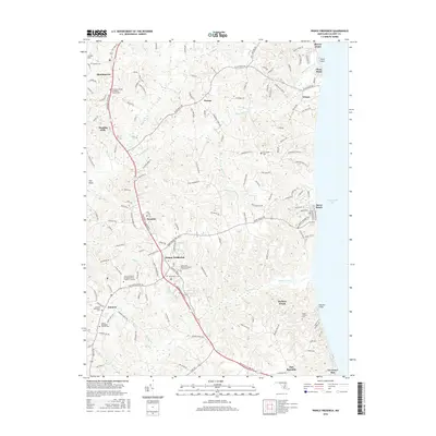
2016 Map of Prince Frederick
USGS Topo · Published 2016About this map
Prince Frederick serves as the central hub of this coastal Calvert County landscape, where the inland settlements of Huntingtown and Barstow transition toward the dramatic Calvert Cliffs and the Chesapeake Bay shoreline. This modern survey illustrates the dense network of local roads and family-named landmarks that define the region's contemporary character. Local history is deeply embedded in the numerous sacred sites scattered throughout the area, from Saint Paul's Cem and Saint John Vianney Catholic Church Cem in the county seat to the outlying Patuxent United Methodist Church Cem. The terrain is deeply incised by numerous waterways including Hunting Cr, Parkers Creek, and Plum Point Creek, which drain the uplands into the bay. Coastal communities like Dares Beach and Breezy Point highlight the enduring draw of the waterfront, while the Coll of Southern Maryland Prince Frederick Campus marks the continued growth of the regional center.
Find a feature on this map
163 named features on this map. Tap any name to fly to it.
Don’t see what you’re looking for? This feature index may not catch every label — zoom into the map to look around manually.
Map Details
Editions of this 2016 Prince Frederick Map
This is the sole edition of this map. No revisions or reprints were ever made.
Other maps of this area

1892 · Leonardtown
USGS Topo · 1:62,500

1892 · Drum Point
USGS Topo · 1:62,500

1892 · Prince Frederick
USGS Topo · 1:62,500

1893 · Sharps Island
USGS Topo · 1:62,500

1895 · Prince Frederick
USGS Topo · 1:62,500

1895 · Leonardtown
USGS Topo · 1:62,500

1895 · Nomini
USGS Topo · 1:125,000

1898 · Choptank
USGS Topo · 1:125,000

1898 · Nomini
USGS Topo · 1:125,000

1898 · St. Marys
USGS Topo · 1:125,000