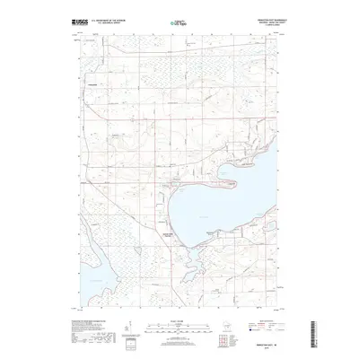
2018 Map of Princeton East
USGS Topo · Published 2018About this map
Green Lake dominates the central and eastern portions of this Wisconsin landscape, where its deep waters meet complex shoreline features like Norwegian Bay and Quimby Bay. To the west, the Fox River meanders through low-lying marshlands before entering Puckaway Lake, illustrating the hydrological connection between these major water bodies. The settlement of Princeton occupies the northwestern corner, while Green Lake Terrace sits along the southwestern shore of the big lake. For those researching local families, the map identifies several rural burying grounds including Dayton Cem, Weiser Cem, and Mount Tom Cem near the prominent elevation of Mount Tom. The road network, including the winding Sunset Rd and Old Green Lake Rd, traces the varied topography between the river basin and the high ground of the Sugarloaf.
Find a feature on this map
82 named features on this map. Tap any name to fly to it.
Don’t see what you’re looking for? This feature index may not catch every label — zoom into the map to look around manually.
Map Details
Editions of this 2018 Princeton East Map
This is the sole edition of this map. No revisions or reprints were ever made.
Other maps of this area

1915 · Neshkoro
USGS Topo · 1:48,000

1916 · Ripon
USGS Topo · 1:48,000

1918 · Neshkoro
USGS Topo · 1:62,500

1918 · Ripon
USGS Topo · 1:62,500

1955 · Randolph
USGS Topo · 1:62,500

1955 · Fox Lake
USGS Topo · 1:62,500

1956 · Ripon
USGS Topo · 1:62,500

1957 · Madison
USGS Topo · 1:250,000

1960 · Madison
USGS Topo · 1:250,000

1963 · Neshkoro
USGS Topo · 1:62,500