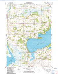
1984 Map of Princeton East
USGS Topo · Published 1984About this map
The Fox River and Puchyan River define the marshy northern reaches of this landscape, while the deep expanse of Green Lake dominates the south. In the mid-1980s, this area shows a transition between the established river town of Princeton and the growing recreational focus of Green Lake Terrace. Local genealogy is well-supported by several family and township burial grounds, including Mt Tom Cem, Weiser Cem, and Dayton Cem. Transportation history is clearly visible in the Old Railroad Grade cutting across the wetlands and the Old Indian Treaty Bdy which still influenced property lines and land divisions. From the Bed-Ah-Wick Landing Field to the numerous bays like Norwegian Bay and Beyers Cove, the map documents a region deeply tied to its water and varied glaciated terrain, including features like the Sugarloaf and Lone Tree Point.
Find a feature on this map
49 named features on this map. Tap any name to fly to it.
Don’t see what you’re looking for? This feature index may not catch every label — zoom into the map to look around manually.
Map Details
Editions of this 1984 Princeton East Map
This is the sole edition of this map. No revisions or reprints were ever made.
Other maps of this area

1915 · Neshkoro
USGS Topo · 1:48,000

1916 · Ripon
USGS Topo · 1:48,000

1918 · Neshkoro
USGS Topo · 1:62,500

1918 · Ripon
USGS Topo · 1:62,500

1955 · Randolph
USGS Topo · 1:62,500

1955 · Fox Lake
USGS Topo · 1:62,500

1956 · Ripon
USGS Topo · 1:62,500

1957 · Madison
USGS Topo · 1:250,000

1960 · Madison
USGS Topo · 1:250,000

1963 · Neshkoro
USGS Topo · 1:62,500