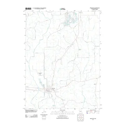
2012 Map of Princeton
USGS Topo · Published 2012About this map
Princeton serves as the central hub for this portion of Mercer County, situated at the confluence of several local routes near the Weldon River. The town grid is clearly defined, with streets like S College Ave and Ballew St providing a look at the community's residential and commercial core. To the north, a cluster of residential lakes including Lake Marie, Twin Lake, and Hidden Valley Lake highlights a shift toward recreation and planned development in the early 21st century. The landscape is further shaped by several smaller waterways such as Wildcat Creek and Muddy Creek. For those researching local heritage, the map identifies critical landmarks including Mercer Cemetery, Underwood Cemetery, and Collins Cemetery. Significant infrastructure is represented by the Princeton-Kauffman Memorial Airport and the Ballast Pit Lake, reflecting both the transportation and industrial history of the region.
Find a feature on this map
74 named features on this map. Tap any name to fly to it.
Don’t see what you’re looking for? This feature index may not catch every label — zoom into the map to look around manually.
Map Details
Editions of this 2012 Princeton Map
This is the sole edition of this map. No revisions or reprints were ever made.
Other maps of this area

1946 · Princeton
USGS Topo · 1:62,500

1948 · Princeton
USGS Topo · 1:62,500

1954 · Centerville
USGS Topo · 1:250,000

1957 · Centerville
USGS Topo · 1:250,000

1958 · Centerville
USGS Topo · 1:250,000

1964 · Ravanna
USGS Topo · 1:24,000

1964 · Half Rock
USGS Topo · 1:24,000

1964 · Pleasanton
USGS Topo · 1:24,000

1964 · Cleopatra
USGS Topo · 1:24,000
1964 · Lineville
USGS Topo · 1:24,000