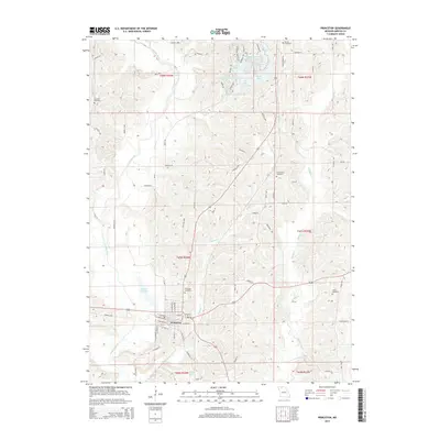
2014 Map of Princeton
USGS Topo · Published 2014About this map
Princeton serves as the focal point of this North Missouri landscape, where the town layout reflects a convergence of local commerce and historic road networks near the Weldon River. The topography is defined by the river’s winding course and the parallel flow of Muddy Creek and Wildcat Creek, creating a series of ridges that host several family and community burial grounds. These include Mercer Cemetery, Underwood Cemetery, and Collins Cemetery, which provide vital touchpoints for genealogical research in Mercer County. To the north, a significant concentration of water bodies like Mercer Lake, Lake Marie, and the Hidden Valley Reservoir indicates a landscape heavily modified for recreation and water management. This 2014 survey documents the modern footprint of the area, showing how residential developments and rural transit routes like Old Highway 65 integrate with the natural drainage basins of the Missouri interior.
Find a feature on this map
87 named features on this map. Tap any name to fly to it.
Don’t see what you’re looking for? This feature index may not catch every label — zoom into the map to look around manually.
Map Details
Editions of this 2014 Princeton Map
This is the sole edition of this map. No revisions or reprints were ever made.
Other maps of this area

1946 · Princeton
USGS Topo · 1:62,500

1948 · Princeton
USGS Topo · 1:62,500

1954 · Centerville
USGS Topo · 1:250,000

1957 · Centerville
USGS Topo · 1:250,000

1958 · Centerville
USGS Topo · 1:250,000

1964 · Ravanna
USGS Topo · 1:24,000

1964 · Half Rock
USGS Topo · 1:24,000

1964 · Pleasanton
USGS Topo · 1:24,000

1964 · Cleopatra
USGS Topo · 1:24,000
1964 · Lineville
USGS Topo · 1:24,000