
1894 Map of Princeton
USGS Topo · Published 1894About this map
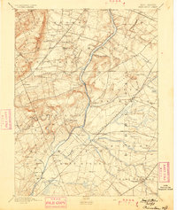
Princeton and its surrounding university landscape appear here alongside the vital transportation corridors of Central New Jersey. The Delaware and Raritan Canal follows the course of the Millstone River, serving as a primary industrial artery before the complete dominance of rail. To its west, the Philadelphia and Reading Railroad cuts through the township of Montgomery, while the Pennsylvania Railroad anchors major junctions to the east.
Find a feature on this map
84 named features on this map. Tap any name to fly to it.
Don’t see what you’re looking for? This feature index may not catch every label — zoom into the map to look around manually.
Map Details
Editions of this 1894 Princeton Map
2 editions found
Other maps of this area

1888 · Plainfield
USGS Topo · 1:62,500

1888 · Bordentown
USGS Topo · 1:62,500

1888 · New Brunswick
USGS Topo · 1:62,500

1888 · Princeton
USGS Topo · 1:62,500

1888 · Cassville
USGS Topo · 1:62,500

1890 · High Bridge
USGS Topo · 1:62,500

1890 · Lambertville
USGS Topo · 1:62,500

1890 · Burlington
USGS Topo · 1:62,500

1891 · Somerville
USGS Topo · 1:62,500

1891 · Lambertville
USGS Topo · 1:62,500
Featured Places
- Hamilton Township, NJ
- Franklin Township, NJ
- South Brunswick, NJ
- North Brunswick Township, NJ
- Hillsborough Township, NJ