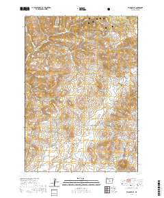
2020 Map of Pringle Flat
USGS Topo · Published 2020About this map
Ochoco National Forest defines the northern reaches of this central Oregon landscape, where the high desert terrain transitions into timbered slopes. The map centers on the namesake Pringle Flat, an area marked by a network of seasonal watercourses and remote access routes. Water management is central to the local geography, anchored by the Klootchman Cr Reservoir and its feeding stream, Klootchman Cr.
Find a feature on this map
21 named features on this map. Tap any name to fly to it.
Don’t see what you’re looking for? This feature index may not catch every label — zoom into the map to look around manually.
Map Details
Editions of this 2020 Pringle Flat Map
This is the sole edition of this map. No revisions or reprints were ever made.
Other maps of this area

1946 · Eagle Rock
USGS Topo · 1:62,500

1948 · Eagle Rock
USGS Topo · 1:62,500

1951 · Post
USGS Topo · 1:62,500

1955 · Crescent
USGS Topo · 1:250,000

1955 · Bend
USGS Topo · 1:250,000

1957 · Crescent
USGS Topo · 1:250,000

1957 · Bend
USGS Topo · 1:250,000

1958 · Crescent
USGS Topo · 1:250,000

1958 · Bend
USGS Topo · 1:250,000
1967 · Sugarloaf Butte
USGS Topo · 1:24,000