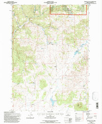
1992 Map of Pringle Flat
USGS Topo · Published 1997About this map
Ochoco National Forest land and ranching operations define this high desert landscape in Crook County. The presence of the Held (Site) and the Circle F Ranch indicates the sparse but deliberate settlement pattern required for survival in this arid environment. Water management is the central theme of the terrain, visible through a network of vital resources like the Pringle Flat Reservoir and Klootchman Cr Reservoir, alongside smaller improvements such as the Shorty Gay Well and BB Spring.
Find a feature on this map
31 named features on this map. Tap any name to fly to it.
Don’t see what you’re looking for? This feature index may not catch every label — zoom into the map to look around manually.
Map Details
Editions of this 1992 Pringle Flat Map
This is the sole edition of this map. No revisions or reprints were ever made.
Other maps of this area

1946 · Eagle Rock
USGS Topo · 1:62,500

1948 · Eagle Rock
USGS Topo · 1:62,500

1951 · Post
USGS Topo · 1:62,500

1955 · Crescent
USGS Topo · 1:250,000

1955 · Bend
USGS Topo · 1:250,000

1957 · Crescent
USGS Topo · 1:250,000

1957 · Bend
USGS Topo · 1:250,000

1958 · Crescent
USGS Topo · 1:250,000

1958 · Bend
USGS Topo · 1:250,000
1967 · Sugarloaf Butte
USGS Topo · 1:24,000