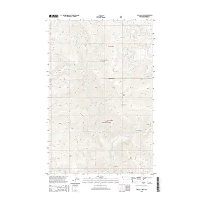
2014 Map of Priscilla Peak
USGS Topo · Published 2014About this map
Lolo National Forest encompasses this high-elevation terrain within Sanders County, where the topography is defined by the drainage systems of the Thompson River and the W Fork Thompson River. The landscape is anchored by prominent summits such as Priscilla Peak and Liver Peak, which overlook a network of drainages including Priscilla Gulch and Sleepy Gulch. This 2014 survey captures the intricate water system of the Cabinet Mountains region, featuring the small but distinct Honeymoon Lake and various tributaries like Honeymoon Cr and Deerhorn Cr. Local landmarks such as Sundance Ridge and the View Point east of the main river fork provide specific orientation points within this densely forested wilderness area. The map illustrates the specialized land management and section divisions typical of federal forest lands, providing a precise record of the natural hydrology and elevation gradients that define this part of western Montana.
Find a feature on this map
41 named features on this map. Tap any name to fly to it.
Don’t see what you’re looking for? This feature index may not catch every label — zoom into the map to look around manually.
Map Details
Editions of this 2014 Priscilla Peak Map
This is the sole edition of this map. No revisions or reprints were ever made.
Other maps of this area

1937 · Thompson Falls
USGS Topo · 1:125,000

1937 · Thompson Falls
USGS Topo · 1:62,500

1956 · Wallace
USGS Topo · 1:250,000

1957 · Thompson Falls
USGS Topo · 1:62,500

1960 · Wallace
USGS Topo · 1:250,000

1964 · Calico Creek
USGS Topo · 1:24,000

1964 · Eddy Mountain
USGS Topo · 1:24,000
1964 · Big Hole Peak
USGS Topo · 1:24,000
1964 · Priscilla Peak
USGS Topo · 1:24,000

1966 · Vermilion Peak
USGS Topo · 1:24,000