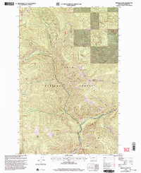
1999 Map of Priscilla Peak
USGS Topo · Published 2003About this map
Priscilla Peak and the high elevations of Sundance Ridge define this corner of the Lolo National Forest in Sanders County. The terrain is structured around the confluence of the West Fork Thompson River and the main Thompson River, showing the drainages that shaped local timber and forest management access. A lookout atop Priscilla Peak and several survey benchmarks like BM 2624 point to the area's history as a monitored wilderness and watershed. The drainage network includes numerous named features such as Four Lakes Creek and Honeymoon Creek, which feeds into the small Honeymoon Lake. These labels, alongside gulches like Sleepy Gulch and peaks such as Liver Peak, provide precise landmarks for those researching the geography of the Cabinet Mountains region at the close of the 20th century.
Find a feature on this map
23 named features on this map. Tap any name to fly to it.
Don’t see what you’re looking for? This feature index may not catch every label — zoom into the map to look around manually.
Map Details
Editions of this 1999 Priscilla Peak Map
This is the sole edition of this map. No revisions or reprints were ever made.
Other maps of this area

1937 · Thompson Falls
USGS Topo · 1:125,000

1937 · Thompson Falls
USGS Topo · 1:62,500

1956 · Wallace
USGS Topo · 1:250,000

1957 · Thompson Falls
USGS Topo · 1:62,500

1960 · Wallace
USGS Topo · 1:250,000

1964 · Calico Creek
USGS Topo · 1:24,000

1964 · Eddy Mountain
USGS Topo · 1:24,000
1964 · Big Hole Peak
USGS Topo · 1:24,000
1964 · Priscilla Peak
USGS Topo · 1:24,000

1966 · Vermilion Peak
USGS Topo · 1:24,000