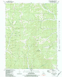
1983 Map of Proctor Creek
USGS Topo · Published 1983About this map
Lake of the Ozarks reaches into the southern margin of this quadrangle, where the small settlement of Proctor sits at the head of a winding arm of the water. The landscape is defined by the heavy dissection of the Buffalo and Haw Creek regions, characterized by a dense network of hollows that reflect long-standing local naming traditions, such as Indian Camp Hollow, Sugar Camp Hollow, and Coon Rod Hollow.
Find a feature on this map
43 named features on this map. Tap any name to fly to it.
Don’t see what you’re looking for? This feature index may not catch every label — zoom into the map to look around manually.
Map Details
Editions of this 1983 Proctor Creek Map
This is the sole edition of this map. No revisions or reprints were ever made.
Other maps of this area

1887 · Warsaw
USGS Topo · 1:125,000

1888 · Versailles
USGS Topo · 1:125,000

1893 · Versailles
USGS Topo · 1:125,000

1894 · Warsaw
USGS Topo · 1:125,000

1904 · Gravois Mills
USGS Topo · 1:62,500

1934 · Purvis
USGS Topo · 1:24,000

1934 · Irontown Ferry
USGS Topo · 1:24,000

1935 · Gravois Mills
USGS Topo · 1:24,000

1935 · Proctor Creek
USGS Topo · 1:24,000

1935 · Boylers Mill
USGS Topo · 1:24,000