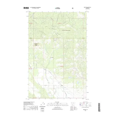
2020 Map of Proctor
USGS Topo · Published 2020About this map
Proctor sits at the transition between the agricultural floor of Big Meadows Rd and the rising timberlands of the Flathead National Forest. This 2020 survey reveals a landscape defined by water and winter recreation, with the northern slopes of Blacktail Mtn and Kerr Mtn featuring a dense network of snow-specific trails such as Telemark Descent and Lakeside Glide. These routes descend toward the basin where Webb Lake and Grants Meadow provide drainage for the W Fork Dayton Cr. Further south, the settlement pattern centers on the namesake village and landmarks like Red Lake, while Proctor School Rd points to the area's local civic history. The map also documents numerous water sources critical to the high-mountain geography, including Indian Spring, Foss Spring, and the various forks of Dayton Creek.
Find a feature on this map
50 named features on this map. Tap any name to fly to it.
Don’t see what you’re looking for? This feature index may not catch every label — zoom into the map to look around manually.
Map Details
Editions of this 2020 Proctor Map
This is the sole edition of this map. No revisions or reprints were ever made.
Other maps of this area

1920 · Flathead Lake
USGS Topo · 1:125,000

1943 · Kalispell
USGS Topo · 1:125,000

1956 · Wallace
USGS Topo · 1:250,000

1957 · Kalispell
USGS Topo · 1:250,000

1960 · Kalispell
USGS Topo · 1:250,000

1960 · Wallace
USGS Topo · 1:250,000

1961 · Kalispell
USGS Topo · 1:250,000

1962 · Kila
USGS Topo · 1:24,000

1962 · Lion Mountain
USGS Topo · 1:24,000

1962 · Somers
USGS Topo · 1:24,000