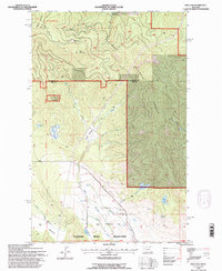
1994 Map of Proctor
USGS Topo · Published 1996About this map
Proctor sits at the intersection of mountain timberlands and high-altitude meadows in Lake County, Montana. The landscape is defined by the Flathead Indian Reservation boundary and the Flathead National Forest, reflecting a complex pattern of land management and natural resources. Public lands are crisscrossed by the Blacktail-Wildbill ORV National Recreation Trail, which winds past Blacktail Mountain and Kerr Mountain. The area’s hydrological network includes the branching West, Middle, and East Fork of the local creeks, feeding into basins like Basin Meadows and Gentrys Meadows. At the heart of the small settlement, the Community Ch and a nearby Pumping Sta mark the local infrastructure, while smaller water features like Mikes Pond, Skags Lake, and Bow Lake dot the valleys between the ridges.
Find a feature on this map
31 named features on this map. Tap any name to fly to it.
Don’t see what you’re looking for? This feature index may not catch every label — zoom into the map to look around manually.
Map Details
Editions of this 1994 Proctor Map
This is the sole edition of this map. No revisions or reprints were ever made.
Other maps of this area

1920 · Flathead Lake
USGS Topo · 1:125,000

1943 · Kalispell
USGS Topo · 1:125,000

1956 · Wallace
USGS Topo · 1:250,000

1957 · Kalispell
USGS Topo · 1:250,000

1960 · Kalispell
USGS Topo · 1:250,000

1960 · Wallace
USGS Topo · 1:250,000

1961 · Kalispell
USGS Topo · 1:250,000

1962 · Kila
USGS Topo · 1:24,000

1962 · Lion Mountain
USGS Topo · 1:24,000

1962 · Somers
USGS Topo · 1:24,000