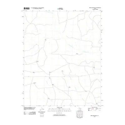
2010 Map of Proctor Ranch
USGS Topo · Published 2010About this map
Proctor Ranch serves as a primary point of human activity in this vast High Plains landscape of Hartley County. The land is defined by a sparse network of essential water sources, including the meandering Punta de Agua Creek and the southern reaches of Sand Creek. This environment, typical of the Texas Panhandle ranching tradition, is mapped through the placement of numerous windmills that provide water for livestock across wide pastures. These features, often named for terrain or family, include the Low Draw Windmill, Wallace Windmill, and Cruz Windmill. Human infrastructure is otherwise limited to the corridor of FM 767, which cuts east-to-west across the terrain, and a singular Oil Well Windmill hinting at the subsurface resources of the region. The map captures the quiet, utilitarian geometry of contemporary ranch life where water management remains the most critical marker of the landscape.
Find a feature on this map
17 named features on this map. Tap any name to fly to it.
Don’t see what you’re looking for? This feature index may not catch every label — zoom into the map to look around manually.
Map Details
Editions of this 2010 Proctor Ranch Map
This is the sole edition of this map. No revisions or reprints were ever made.
Other maps of this area

1954 · Tucumcari
USGS Topo · 1:250,000

1958 · Tucumcari
USGS Topo · 1:250,000

1971 · Proctor Ranch
USGS Topo · 1:24,000

1971 · Channing NW
USGS Topo · 1:24,000

1971 · Many Post Camp
USGS Topo · 1:24,000
1971 · Torrey House
USGS Topo · 1:24,000
1971 · Humdinger Spring
USGS Topo · 1:24,000

1971 · Pedarosa Camp
USGS Topo · 1:24,000

1972 · Hartley SW
USGS Topo · 1:24,000

1973 · King SW
USGS Topo · 1:24,000