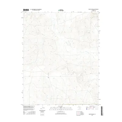
2016 Map of Proctor Ranch
USGS Topo · Published 2016About this map
Proctor Ranch serves as a primary landmark in this section of Hartley County, where the High Plains landscape is defined by a network of drainage systems. The hydrologic character of the region is evident in the winding courses of Punta de Agua Cr, Sand Cr, and Moneto Cr, which carve through the terrain and influence local land use. This 2016 survey illustrates the sparsely populated nature of the Texas Panhandle, where large ranching operations like the Proctor Ranch are the central hubs of activity. Transportation is facilitated by FM 767, a farm-to-market road that provides a rare paved artery through this rural expanse, connecting isolated property markers and water sources in an environment where topographic elevation changes guide the placement of stock tanks and boundary lines.
Find a feature on this map
5 named features on this map. Tap any name to fly to it.
Don’t see what you’re looking for? This feature index may not catch every label — zoom into the map to look around manually.
Map Details
Editions of this 2016 Proctor Ranch Map
This is the sole edition of this map. No revisions or reprints were ever made.
Other maps of this area

1954 · Tucumcari
USGS Topo · 1:250,000

1958 · Tucumcari
USGS Topo · 1:250,000

1971 · Proctor Ranch
USGS Topo · 1:24,000

1971 · Channing NW
USGS Topo · 1:24,000

1971 · Many Post Camp
USGS Topo · 1:24,000
1971 · Torrey House
USGS Topo · 1:24,000
1971 · Humdinger Spring
USGS Topo · 1:24,000

1971 · Pedarosa Camp
USGS Topo · 1:24,000

1972 · Hartley SW
USGS Topo · 1:24,000

1973 · King SW
USGS Topo · 1:24,000