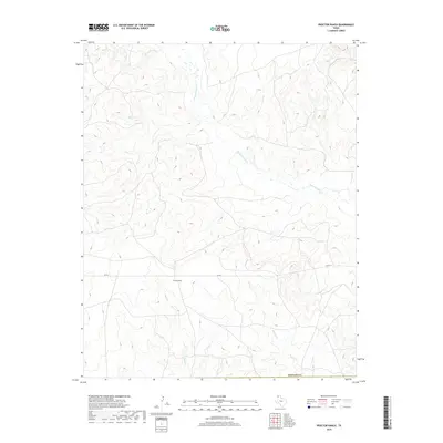
2019 Map of Proctor Ranch
USGS Topo · Published 2019About this map
Proctor Ranch sits at the center of this 2019 survey, representing the enduring cattle-ranching heritage of the Texas Panhandle. Located within Hartley County, the landscape is defined by the ephemeral drainage systems of the High Plains, where the headwaters of Punta de Agua Cr wind through the northern terrain. The layout of the land reflects the traditional large-acreage holdings of the region, anchored by the ranch and bisected by FM 767. This remote corner of Texas remains largely defined by its natural watercourses, including Sand Cr and Moneto Cr, which provide critical seasonal water in a semi-arid environment. The mapping of these drainages offers a detailed look at the geographic features that have dictated settlement patterns and land use in this part of the state for generations.
Find a feature on this map
6 named features on this map. Tap any name to fly to it.
Don’t see what you’re looking for? This feature index may not catch every label — zoom into the map to look around manually.
Map Details
Editions of this 2019 Proctor Ranch Map
This is the sole edition of this map. No revisions or reprints were ever made.
Other maps of this area

1954 · Tucumcari
USGS Topo · 1:250,000

1958 · Tucumcari
USGS Topo · 1:250,000

1971 · Proctor Ranch
USGS Topo · 1:24,000

1971 · Channing NW
USGS Topo · 1:24,000

1971 · Many Post Camp
USGS Topo · 1:24,000
1971 · Torrey House
USGS Topo · 1:24,000
1971 · Humdinger Spring
USGS Topo · 1:24,000

1971 · Pedarosa Camp
USGS Topo · 1:24,000

1972 · Hartley SW
USGS Topo · 1:24,000

1973 · King SW
USGS Topo · 1:24,000