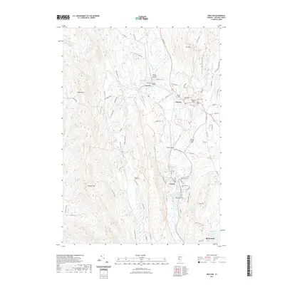
2021 Map of Proctor
USGS Topo · Published 2021About this map
Otter Creek meanders through this Vermont landscape, connecting the industrial and residential centers of Proctor, Pittsford, and Florence. This 2021 update records a region defined by its marble heritage and complex topography, where the valley floor is punctuated by historic crossings such as the Depot Covered Bridge, Hammond Covered Bridge, and Cooley Covered Bridge. Near the village of Proctor, the dramatic drop of Sutherland Falls remains a focal point of the local geography. To the west, the steep rise of Grandpa Knob and Biddie Knob frames the agricultural corridor of Whipple Hollow, while the eastern edge is defined by the Green Mountains. Numerous local burial sites, including the Whipple Hollow Cem and Riverside Cem, offer specific points of interest for genealogical research in these established Rutland County communities.
Find a feature on this map
93 named features on this map. Tap any name to fly to it.
Don’t see what you’re looking for? This feature index may not catch every label — zoom into the map to look around manually.
Map Details
Editions of this 2021 Proctor Map
This is the sole edition of this map. No revisions or reprints were ever made.
Other maps of this area

1891 · Rutland
USGS Topo · 1:62,500

1893 · Rutland
USGS Topo · 1:62,500

1895 · Castleton
USGS Topo · 1:62,500

1897 · Castleton
USGS Topo · 1:62,500

1902 · Brandon
USGS Topo · 1:62,500

1904 · Brandon
USGS Topo · 1:62,500

1915 · Rochester
USGS Topo · 1:62,500

1917 · Rochester
USGS Topo · 1:62,500

1920 · Brandon
USGS Topo · 1:62,500

1944 · Proctor
USGS Topo · 1:31,680