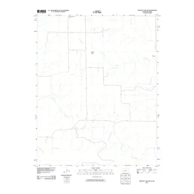
2010 Map of Proffitt Lake SW
USGS Topo · Published 2010About this map
Fivemile Creek and Crooked Creek define the drainage of this rural landscape on the Kansas-Oklahoma border. The land is organized by a strictly orthogonal grid of section roads, including AA Rd and Ee Rd, which connect isolated rural landmarks across the plains. Genealogy researchers will note the Little Congregational Cemetery in the north and the Butler Cemetery to the east, both serving as anchors for the local farming community. Aviation history is represented by the Painter Landing Strip located near the center of the sheet. The map illustrates a contemporary western prairie environment where modern infrastructure like private air strips and county roads overlay the timeless flow of natural creek beds.
Find a feature on this map
16 named features on this map. Tap any name to fly to it.
Don’t see what you’re looking for? This feature index may not catch every label — zoom into the map to look around manually.
Map Details
Editions of this 2010 Proffitt Lake SW Map
This is the sole edition of this map. No revisions or reprints were ever made.
Other maps of this area

1892 · Meade
USGS Topo · 1:125,000

1954 · Perryton
USGS Topo · 1:250,000

1955 · Dodge City
USGS Topo · 1:250,000

1958 · Perryton
USGS Topo · 1:250,000

1958 · Dodge City
USGS Topo · 1:250,000

1959 · Dodge City
USGS Topo · 1:250,000

1962 · Irish Flats NE
USGS Topo · 1:24,000

1962 · Irish Flats SE
USGS Topo · 1:24,000
1970 · Gate NE
USGS Topo · 1:24,000

1970 · Gate NW
USGS Topo · 1:24,000