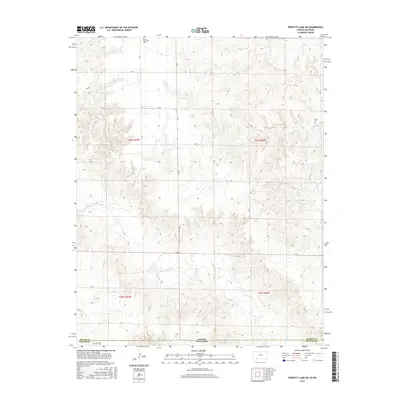
2016 Map of Proffitt Lake SW
USGS Topo · Published 2016About this map
The Kansas-Oklahoma border defines the rugged southern plains landscape where Meade and Beaver counties meet. This high plains region is carved by the winding channels of Crooked Cr and Fivemile Cr, which dictate the local topography amidst a strict rectilinear grid of rural routes such as Z Rd and Aa Rd. The presence of the Kleine Gemeinde Cem in the north and the Butler Cem further east provides concrete evidence of the area's early 20th-century settlement patterns, reflecting the community heritage of the Mennonite and pioneer families who established homesteads in these borderlands. The network of section line roads, including Bb Rd and Ee Rd, reveals how the landscape was systematically organized for agriculture and ranching, preserving a spatial layout that has remained remarkably consistent over the decades.
Find a feature on this map
22 named features on this map. Tap any name to fly to it.
Don’t see what you’re looking for? This feature index may not catch every label — zoom into the map to look around manually.
Map Details
Editions of this 2016 Proffitt Lake SW Map
This is the sole edition of this map. No revisions or reprints were ever made.
Other maps of this area

1892 · Meade
USGS Topo · 1:125,000

1954 · Perryton
USGS Topo · 1:250,000

1955 · Dodge City
USGS Topo · 1:250,000

1958 · Perryton
USGS Topo · 1:250,000

1958 · Dodge City
USGS Topo · 1:250,000

1959 · Dodge City
USGS Topo · 1:250,000

1962 · Irish Flats NE
USGS Topo · 1:24,000

1962 · Irish Flats SE
USGS Topo · 1:24,000
1970 · Gate NE
USGS Topo · 1:24,000

1970 · Gate NW
USGS Topo · 1:24,000