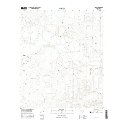
2016 Map of Proffitt
USGS Topo · Published 2016About this map
The Brazos River carves a winding path through the heart of this Young County landscape, defining the topography between the small settlements of Proffitt and Newcastle. This 2016 survey illustrates the persistent rural character of North Texas, where the river bottomlands at Johnson Bottom and the elevated terrain of Deer Head Bluff and Round Mtn shape the layout of ranch roads and property boundaries. Genealogists and local historians will find significant markers of the area's early settlement families at the Proffitt Cem and Woolfolk Cem. The intricate network of seasonal drainage, including Whiskey Cr, California Cr, and Hamby Br, reveals the complex hydrology that supports the local cattle and agricultural operations. Much of the land remains divided by family-named routes such as Strother Rd and Bailey Rd, reflecting a landscape that has changed little in its fundamental structure over many decades.
Find a feature on this map
48 named features on this map. Tap any name to fly to it.
Don’t see what you’re looking for? This feature index may not catch every label — zoom into the map to look around manually.
Map Details
Editions of this 2016 Proffitt Map
This is the sole edition of this map. No revisions or reprints were ever made.
Other maps of this area

1925 · Graham 4-c
USGS Topo · 1:48,000

1927 · Graham
USGS Topo · 1:62,500

1954 · Wichita Falls
USGS Topo · 1:250,000

1958 · Wichita Falls
USGS Topo · 1:250,000

1964 · Newcastle
USGS Topo · 1:24,000

1964 · Padgett
USGS Topo · 1:24,000

1964 · True
USGS Topo · 1:24,000

1964 · Olney
USGS Topo · 1:24,000
1966 · Proffitt
USGS Topo · 1:24,000
1966 · Tackett Mountain
USGS Topo · 1:24,000