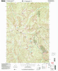
2004 Map of Profile Gap
USGS Topo · Published 2007About this map
Moscow Mine and several other mining operations are clustered around the high mountain passes of the Payette National Forest in this 2004 revision of the 1969 survey. The map details a landscape of extreme verticality, dominated by peaks such as Willson Peak and Dixie Mtn, where the industrial history of the region is evident in the proximity of the Willson Mine, Glasgow Mine, and Red Metals Mine to Profile Gap.
Find a feature on this map
32 named features on this map. Tap any name to fly to it.
Don’t see what you’re looking for? This feature index may not catch every label — zoom into the map to look around manually.
Map Details
Editions of this 2004 Profile Gap Map
This is the sole edition of this map. No revisions or reprints were ever made.
Other maps of this area

1937 · Yellow Pine
USGS Topo · 1:48,000

1937 · Big Creek
USGS Topo · 1:48,000

1942 · Big Creek
USGS Topo · 1:62,500

1943 · Yellow Pine
USGS Topo · 1:62,500

1956 · Elk City
USGS Topo · 1:250,000

1957 · Challis
USGS Topo · 1:250,000

1960 · Elk City
USGS Topo · 1:250,000

1960 · Challis
USGS Topo · 1:250,000

1963 · Challis
USGS Topo · 1:250,000

1969 · Edwardsburg
USGS Topo · 1:24,000