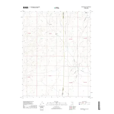
2018 Map of Prohibition Flat
USGS Topo · Published 2018About this map
Prohibition Flat lies along the high-desert border of Iron County, Utah, and Lincoln County, Nevada, where the Paradise Mountains transition into a landscape shaped by seasonal hydrology and historic ranching routes. This area is defined by its critical water sources, such as Prohibition Spring, Newels Spring, and Trough Spring, which would have been vital landmarks for anyone moving through the arid territory. The presence of Rose Valley Reservoir indicates a managed approach to water in a region where naturally occurring drainage like Gold Springs Wash and Midnight Wash provide the primary geographical structure. Navigating this terrain relies on a network of primitive tracks and trails, including the descriptive Devils Trl and the 1st Fork Cutoff Trl, which suggest a history of bypasses and specific localized access points through the canyon systems like Fay Canyon.
Find a feature on this map
30 named features on this map. Tap any name to fly to it.
Don’t see what you’re looking for? This feature index may not catch every label — zoom into the map to look around manually.
Map Details
Editions of this 2018 Prohibition Flat Map
This is the sole edition of this map. No revisions or reprints were ever made.
Other maps of this area

1885 · St. George
USGS Topo · 1:250,000

1885 · Pioche
USGS Topo · 1:250,000

1886 · Pioche
USGS Topo · 1:250,000

1891 · St. George
USGS Topo · 1:250,000

1953 · Cedar City
USGS Topo · 1:250,000

1954 · Caliente
USGS Topo · 1:250,000

1958 · Cedar City
USGS Topo · 1:250,000

1959 · Caliente
USGS Topo · 1:250,000

1962 · Cedar City
USGS Topo · 1:250,000
1972 · Panaca Summit
USGS Topo · 1:24,000