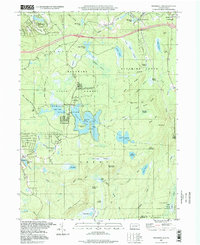
1997 Map of Promised Land
USGS Topo · Published 1998About this map
Promised Land State Park anchor this portion of the Pocono Plateau, where the landscape is defined by an intricate network of glacial lakes and extensive wetland systems like Long Pond Swamp and Balsam Swamp. This 1990s survey shows a region deeply committed to conservation and recreation, with established Campgrounds and Picnic Areas surrounding Promised Land Lake. The presence of Conservation Island and numerous state forest tracts indicates a managed wilderness character preserved against the encroaching development seen in small clusters like Roemersville and Tanglewood. Local institutional history is marked by the Good Shepherd Ch and Blooming Grove Sch in the northeast, while the terrain rises sharply at Bear Trap Mountain and High Knob. The map traces a transition from high-elevation ridges to the deep drainage of Shohola Creek, illustrating the natural water management of the Pennsylvania uplands.
Find a feature on this map
76 named features on this map. Tap any name to fly to it.
Don’t see what you’re looking for? This feature index may not catch every label — zoom into the map to look around manually.
Map Details
Editions of this 1997 Promised Land Map
This is the sole edition of this map. No revisions or reprints were ever made.
Other maps of this area

1919 · Pocono
USGS Topo · 1:62,500

1921 · Pocono
USGS Topo · 1:62,500

1923 · Pocono
USGS Topo · 1:62,500

1924 · Bushkill
USGS Topo · 1:48,000

1928 · Ariel
USGS Topo · 1:62,500

1932 · Ariel
USGS Topo · 1:62,500

1935 · Hawley
USGS Topo · 1:62,500

1938 · Hawley
USGS Topo · 1:62,500

1943 · Bushkill
USGS Topo · 1:62,500

1943 · Pocono
USGS Topo · 1:62,500
Featured Places
- Blooming Grove Township, PA
- Greene Township, PA
- Porter Township, PA
- Tanglewood Estate, Palmyra Township
- Roemersville, Greene Township