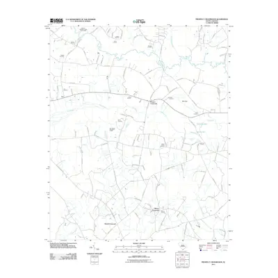
2011 Map of Prospect Crossroads
USGS Topo · Published 2011About this map
The Lynches River winds across the northern reaches of this coastal plain landscape, where dense swamp networks and small rural settlements define the geography of Florence County. Smaller water bodies like Lake Swamp and Big Swamp Branch create a complex hydrography that likely dictated early development and road placement in this region. The map captures the agricultural and residential pockets of Leo and Prospect Crossroads, linked by a web of local routes such as Huggins Rd and N 1st Neck Rd. For genealogists and family historians, the abundance of family-named burial grounds is remarkable, including the Gaskins Cemetery, Baxley Cemetery, and Eaddy-Ford Cemetery. These sites, along with landmarks like the Leo Hanna Pond Dam D-3567, reflect a deeply rooted community structure where land ownership and kinship are tied to specific local terrain features and watercourses.
Find a feature on this map
114 named features on this map. Tap any name to fly to it.
Don’t see what you’re looking for? This feature index may not catch every label — zoom into the map to look around manually.
Map Details
Editions of this 2011 Prospect Crossroads Map
This is the sole edition of this map. No revisions or reprints were ever made.
Other maps of this area

1943 · Henry
USGS Topo · 1:24,000

1946 · Hyman
USGS Topo · 1:62,500

1946 · Johnsonville
USGS Topo · 1:62,500

1946 · Indiantown
USGS Topo · 1:62,500

1949 · Georgetown
USGS Topo · 1:250,000

1967 · Georgetown
USGS Topo · 1:250,000

1974 · Georgetown
USGS Topo · 1:250,000

1986 · Kingstree
USGS Topo · 1:100,000
1990 · Scranton
USGS Topo · 1:24,000
1990 · Pamplico South
USGS Topo · 1:24,000