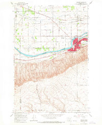
1965 Map of Prosser
USGS Topo · Published 1966About this map
Prosser serves as a vital agricultural and transportation hub in the mid-1960s, defined by its position along the Yakima River. The town's infrastructure is prominently detailed, showing the Courthouse, Library, and Hospital alongside educational landmarks like Prosser High Sch and the Jr High Sch. Industrial and irrigation history is written into the landscape through the Sunnyside Canal and Chandler Canal, which supported the surrounding orchards and fields. To the south, the dramatic rising terrain of the Horse Heaven Hills contrasts with the valley floor, where the Northern Pacific Railroad and Union Pacific Railroad parallel the river. Smaller outlying communities such as Byron and Apricot are visible, along with local aviation at Beardsley Airfield and social centers like the Grange Hall.
Find a feature on this map
71 named features on this map. Tap any name to fly to it.
Don’t see what you’re looking for? This feature index may not catch every label — zoom into the map to look around manually.
Map Details
Editions of this 1965 Prosser Map
3 editions found
Other maps of this area

1915 · Prosser
USGS Topo · 1:125,000

1917 · Prosser
USGS Topo · 1:125,000

1950 · Grandview
USGS Topo · 1:62,500

1951 · Grandview
USGS Topo · 1:62,500

1951 · Corral Canyon
USGS Topo · 1:62,500

1953 · Walla Walla
USGS Topo · 1:250,000

1955 · Prosser SW
USGS Topo · 1:24,000

1958 · Walla Walla
USGS Topo · 1:250,000

1965 · Whitstran
USGS Topo · 1:62,500
1965 · Prosser
USGS Topo · 1:62,500